AI could predict hurricane landfall sooner - report
- Published
- comments

Artificial Intelligence could save lives by warning where a hurricane will hit land much sooner than traditional forecasting systems, researchers say.
A new AI tool from Google DeepMind predicted where September's hurricane Lee would make landfall in Canada three days ahead of existing methods.
Weather forecasts have become much more accurate over the decades.
But AI's speed and ability to analyse past events to make predictions make it a game-changer, say scientists.
An accurate weather forecast is useful to tell you what to wear when you go out in the morning but - much more importantly - can forewarn us of extreme weather like storms, floods and heatwaves, giving communities crucial time to prepare.
However, traditional weather forecasts take vast amounts of computing power.
They involve creating estimates of hundreds of factors including air pressure, temperature, wind speeds and humidity at different levels of the atmosphere around the globe.
A new AI tool called GraphCast created by Google DeepMind outperforms the European Medium Range Weather Forecasting model - one the best in the world - on more than 90% of those factors, according to a peer-reviewed paper published by DeepMind in the journal Science.
GraphCast produces its forecasts in less than a minute, using a fraction of the computing power of traditional forecasting methods because it takes a very different approach.

Weather forecasts prepare us for a rainy day out, but they also warn of potentially deadly weather events
Traditional weather forecasting involves taking measurements of what is happening in the atmosphere right now.
The best models take in hundreds of millions of readings from around the world every day.
These come from a huge range of sources including weather stations, satellites, balloons sent up in the atmosphere, buoys in the ocean - even readings taken by sensors on the noses of commercial jet planes.
"We then use our model to select which are going to be the most important," explains Matthew Chantry, of the European Centre for Medium Range Weather Forecasting (ECMRWF) who says about 10 million of the measurements will be used for one of its forecasts.
This ocean of data is fed into a supercomputer to be processed by programmes which can do quadrillions (a thousand trillion) of calculations every second. These use complex equations to simulate what happens in the Earth's atmosphere to predict how the weather will change and evolve over time.
This method has been extraordinarily successful. As the models have improved and the computers have got more powerful over the decades, weather forecasts have got significantly more accurate.
But these numerical weather prediction (NWP) models, as they are known, take vast amounts of computer resources, using some of the biggest supercomputers in the world and typically take hours to produce their forecasts.
A new approach
AI shortcuts much of this effort. It does not try to model how the world works.
Instead, GraphCast uses machine learning to digest vast quantities of historical data - including the output of the ECMRWF model - to learn how weather patterns evolve.
It uses this knowledge to predict how the weather now is likely to change in the future.
And it is proving very effective.
"The main advantage of this AI approach is that it's extremely accurate," said Remy Lam of Google DeepMind, who helped create the weather tool.
"It learns from decades of data and is able to be more accurate than the industry gold standard," he says.
And, because it does not try to solve complex equations, it can make its forecasts very quickly and using much less computing power.
GraphCast's forecasts are not as detailed as those produced by the ECMRWF but it is better at predicting severe events like extreme temperatures and at tracking the path of big storms.
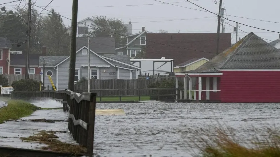
Hurricane Lee - an early prediction of landfall
It accurately predicted where Hurricane Lee, a storm that hit the Atlantic coast of the US and Canada in September, would make landfall, for example.
Deep Mind's AI tool predicted its path nine days ahead, the ECMRWF only managed six days ahead.
But the success of GraphCast does not mean we can shut down the supercomputers and rely on AI instead.
Even Remy Lam from Google DeepMind says that will not happen.
'Huge leaps forward'
"We are standing on the shoulders of giants to build those models", he says.
Rather than replacing traditional weather forecasts AI models will complement them, he believes.
"AI models are trained from data and that data is generated by traditional approaches, so we still need the traditional approach to gather data to train the model," says Mr Lam.
GraphCast is open source which means Google DeepMind is sharing the details of the design so anyone can use the technology.
Many technology companies and weather and climate organisations around the world are designing their own AI weather prediction tools.
The Met Office, the UK's national weather service, is working with the Turing Institute, the country's data science centre to explore the potential for AI to improve weather forecasting, for example.
"Weather forecasts derived from artificial intelligence and machine learning are taking huge leaps forward," acknowledges Prof Simon Vosper, the Met Office's Director of Science.
But he warns climate change will limit the predictive power of AI based tools.
"We are seeing new climate-related weather extremes, such as last year's 40C temperatures in the UK that would haven't been realised in former times", says Prof Vosper.

Hurricane Otis became a category five storm in just 24 hours
The way extreme weather systems evolve may also be changing.
Hurricane Otis rapidly intensified from a tropical storm into the strongest category 5 hurricane over just 24 hours in October before making devastating landfall on the coast of southern Mexico.
Climate scientists warn rising ocean temperatures are likely to make this process of rapid intensification of storms more common.
"So it is fair to question whether AI-based systems are able to pick up new extremes if these systems have only been 'trained' on previous weather conditions," suggests Prof Vosper.
Related Topics
- Published16 June 2023
- Published21 August 2023
- Published19 September 2023